From a global public health perspective, the two most important air pollutants are PM and its components and ground-level O3. Ambient PM may be emitted directly as a fine particle (e.g. BC, OC and soil dust) or formed in the atmosphere from emissions of gaseous precursors (e.g. SO2, NOX, NH3 and NMVOC). Ground-level O3 is not directly emitted but is formed in the atmosphere from reactions of NOX, NMVOC, CH4 and CO (Seinfeld and Pandis 2016). Globally, the highest annual average concentrations of PM2.5 are seen in areas affected by windblown sand and dust (e.g. northern Africa and west Asia), fires (e.g. Central Africa and Latin America) and anthropogenic pollution (e.g. South and East Asia) (Cohen et al. 2017; Shaddick et al. 2018) (see Figure 5.7). From 1998 to 2012, satellite observations suggest that PM2.5 decreased significantly over eastern North America, and increased over west Asia, South Asia and East Asia (Boys et al. 2014). Ground-based measurements suggest that the trends over North America, South Asia and East Asia are associated with changes in anthropogenic pollution, but the changes over west Asia are due to changes in windblown sand and dust (Boys et al. 2014).
Ground-level O3 is highest in the northern mid latitudes and tropics, and peaks in the warm season. North America, the Mediterranean, South Asia and East Asia are hotspots for O3 pollution (see Figure 5.8). However, high population weighted O3 concentrations are also estimated in Central Africa, west Asia and South-East Asia (Health Effects Institute 2017).
Satellite observations have identified rapid changes in the ground-level concentrations of SO2 and NO2 over the last 10-15 years, with declining trends in Europe and North America, and increasing trends in some regions in East Asia, South Asia, Africa and South America (Schneider, Lahoz and van der A 2015; Geddes et al. 2016; Krotkov et al. 2016).
Urban areas, which are home to over half of the world’s population, have higher overall levels of air pollution. A review of published PM2.5 observations for 71 megacities (over 5 million people) for 2013 found that, of the 45 megacities with available observations, only 4 attained the WHO guideline for annual average concentrations (Cheng et al. 2016) (Figure 5.9).
Cities with the highest levels were clustered in east-central China and the Indo-Gangetic Plain. Many cities in low- and middle-income countries lack available measurements, but where data is available, 98 per cent of cities exceed the WHO guidelines for PM2.5 or PM10, compared with the 56 per cent of cities in high-income countries with available data (WHO 2016b).
Traffic, residential fuel burning, electricity generation, industry and agriculture all contribute to urban air pollution, although the contribution of different sectors in individual cities can vary significantly (Karagulian et al. 2015). In growing cities across Africa, Asia and other developing regions, there has been an unprecedented rapid increase in the number of vehicles, driven by population growth and economic development (e.g. Adiang et al. 2017). It is projected that by 2030 there will be 41 megacities (population greater than 10 million), the majority in developing countries (United Nations 2016b). Impacts of the pollution from megacities extends far beyond the urban area with effects at local, regional and global scales (Ang’u, Nzioka and Mutai 2016; WHO 2016b).
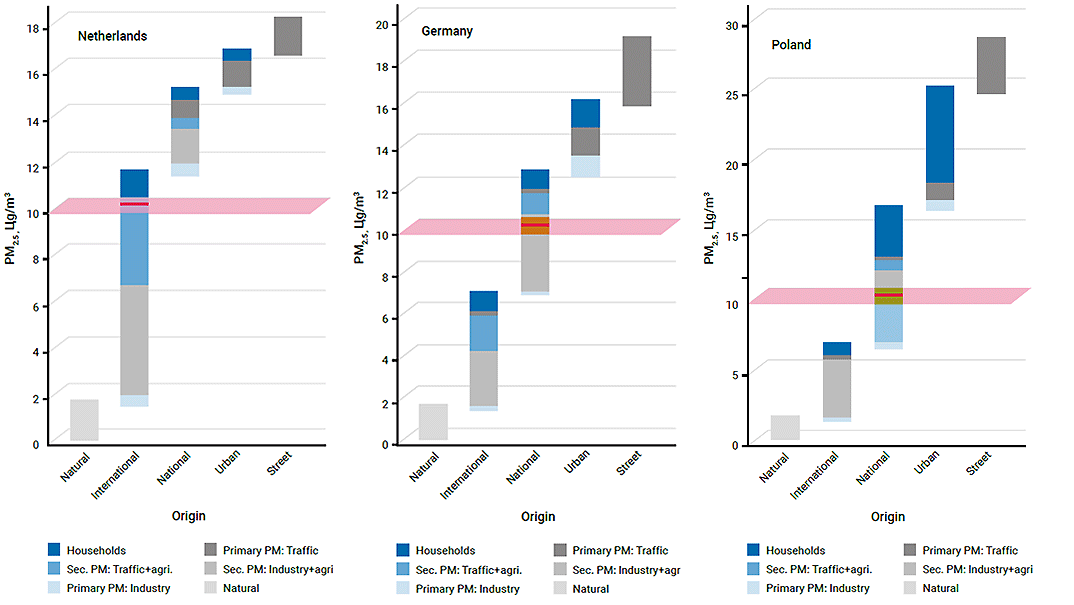
Air pollution observed in any given location may be comprised of contributions from local, regional and even global sources (Figure 5.10).
Better global models, additional monitoring and field studies, and accumulated observations from satellitebased instruments have improved our understanding of the processes and trends that drive such long-range transport of pollution. However, quantifying the absolute contributions of distant sources to observed values on a given day remains challenging. Data assembled for the Tropospheric O3 Assessment Report (TOAR) demonstrates that recent trends in peak values upon which most health-based standards are founded are strongly decreasing in North America and Europe, and strongly increasing in parts of East Asia. However, for summer daytime average O3 concentrations, the trends are more mixed in North America and Western Europe, with some sites showing significant increases (Chang et al. 2017; Schultz et al. 2017). This finding is consistent with observations of increasing ‘background’ O3 above the boundary layer throughout the Northern Hemisphere (Task Force on Hemispheric Transport of Air Pollution 2010; Parrish et al. 2014). The observed increasing trend in global tropospheric O3 from 1980 to 2010 may be due primarily to an equatorward shift in the distribution of global precursor emissions, the effect of which is larger than the increase in global methane and the total mass of other precursor emissions combined (Zhang et al. 2016).
The largest source of particulate matter in the atmosphere globally, on an annual basis, is windblown sand and dust. A ‘dust belt’ extends from the west coast of North Africa, over the Mediterranean Basin, the Middle East, Central and South Asia, to Mongolia and China (see Figure 5.11). This encompasses both natural areas, such as the Sahara and Taklamakan deserts, as well as agricultural areas. Outside the dust belt, sand and dust storms (SDS) are less prevalent; however, SDS can have important local impacts in central Australia, Southern Africa (Botswana and Namibia), the Atacama in South America, and the North America Great Basin (UNEP, WMO and UNCCD 2016). People influence dust sources through land clearing and land management practices and other influences on desertification (see Section 8.4.2). UNEP, WMO and UNCCD (2016) concluded that there has been little change in the frequency and severity of SDS in North Africa, the Middle East and South America over the last 30 years, but significant increases have been observed in North America, Central Asia and Australia. Klingmuller et al. (2016) found an increasing trend in dust over large parts of the Middle East during the period 2001 to 2012 that is correlated with climatic changes.
Transported dust contributes to a wide range of impacts: it affects climate and precipitation patterns; fertilizes distant forests and oceans; contributes to human respiratory ailments; and spreads human, animal and plant pathogens far downwind of the source region. Within the source region, dust storms may damage infrastructure, interrupt transportation and communication systems, and cause air and road traffic accidents. To better understand, forecast and mitigate these impacts, WMO has established a global Sand and Dust Storm Warning Advisory and Assessment System (SDS-WAS) (UNEP, WMO and UNCCD 2016; WMO 2017b).
Fires, primarily associated with land clearing or lightning, are another large contributor to transboundary pollution. In South-East Asia, perennial forest and peatland fires associated, primarily with slash-and-burn agriculture, intensify during dry seasons (Page and Hooijer 2016; Wijedasa et al. 2017). In 2015, fires blanketed the region with smoke, leading to an estimated 100,000 premature deaths associated with air pollution exposure, mostly in Indonesia (Koplitz et al. 2016) (see Section 12.2.5). Boreal forest fires in Siberia, Canada and Alaska contribute to the deposition of BC and other particles in the Arctic, darkening the surface of snow and ice and accelerating melting (Arctic Monitoring and Assessment Programme [AMAP] 2011; AMAP 2015).